
Dave – the editor
Preamble
This piece is intended to look at how the systems and structures many people take for granted and assume are there to serve us – and in the event of emergencies protect us – are actually, disjointed, dysfunctional and failing. A number of posts recently published on our sister blog, the Thurrock and Basildon Heckler about the flooding that hit Thurrock (amongst many other areas) on January 14 have been used in compiling this post.
Rather than discuss these issues in the abstract, I’ve used these posts to highlight where parts of the system effectively failed us. The specific failings addressed are a planning system that allows new homes to be built on a floodplain, poor management of an over-budget, behind schedule road widening project and lastly, failure to check and maintain flood defences such as sluice gates properly.
It’s only by understanding how the system we live under is failing and why that is, that we’ll be able to work out how things could be a lot better if power and responsibility was brought right down to the grassroots. Hopefully, this post will be a useful contribution to this process.
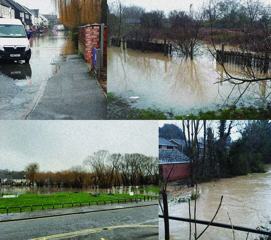
The Stanford-le-Hope flood
On January 13, there was a news item about work commencing this coming autumn on a new housing development adjacent to Victoria Road in Stanford-le-Hope: Homes on new borough housing estate will be brought in by lorry. The land in question is adjacent to the River Hope which runs into Mucking Creek. The site in question is basically on a flood plain and a fair few residents in Stanford-le-Hope have questioned the wisdom of Thurrock Council allowing this development to go ahead.
Well, on January 14, after a night of continuous, heavy rain, Mother Nature gave her answer to the hubris of Thurrock Council and the developers by inundating Stanford-le-Hope (and many other areas across the south of Essex) with floodwater. Here’s how it was covered in the local media: Flooding in Stanford-le-Hope as firefighters join residents trying to keep water at bay. How the morning developed via our video reports. Weather forecast is for more rain. The site of the proposed housing development adjacent to Victoria Road was flooded in parts with the rest of it being severely waterlogged.
Workers in the industrial estate where the Fisons plant used to be and residents in the cottages on Wharf Road to the south of the railway line going down to the London Gateway superport were cut off for a period by flooding under the railway bridge: Industrial estate workers and residents trapped by flooding in Stanford-le-Hope. Canoe is one way to get home! Flooding under this bridge has been an issue for decades: Residents ‘thanked for patience’.
Without giving away too much information, the two of us behind Estuary Stirrings and the Heckler have lived in Stanford-le-Hope since the mid 1980s and this is the worst flooding we’ve ever seen. There was fairly frequent flooding in the 1990s and 2000s but not to the level we saw on January 14. In the mid 2000s, we thought the flooding issue had been more or less resolved with the installation of extra equipment in the pumping station at St. Margaret’s. Wrong!
Planning failures and a botched infrastructure project
Questions need to be asked as to how the heck we’ve been plunged into this situation – literally as well as metaphorically! Let’s start off with the new housing that’s been going up in and around Stanford-le-Hope. As well as various bits of infill and building on former brownfield sites, there has been a fair sized new estate built on part of what used to be part of the golf course at St. Clere’s. Like most new housing developments, the housing density is pretty high and even the upmarket homes only have pocket sized gardens. There’s a lot of hardstanding as well. As you can imagine, there’s little scope for rainwater hitting that estate to do anything other than run off down the slope towards the rest of the built up areas in Stanford-le-Hope. Factor in the doubts as to whether the local sewage and drainage systems were properly expanded to cope with the pressures this development would bring and you can see why that is one of the contributory factors to the flooding.
Then there’s the new Stanford Meadows estate being built by Persimmon on land to the west of the railway line and to the south of the slip road leading up to the junction between the A13 and The Manorway. Like the land scheduled for development adjacent to Victoria Road, Stanford Meadows is being built on what to all intents and purposes is a flood plain. When Persimmon held a ‘consultation’ about this development a few years ago, we dutifully went along to tell them there would be issues building on a floodplain. The representatives for Persimmon said they would be leaving some land vacant where there would be two ponds to deal with any flooding issues. On January 14, both of those ponds were overwhelmed sending floodwater towards residents in Poley Road, Butts Road and Kingsman Road.
When it comes to planning in Thurrock, there’s a lack of joined up, holistic thinking. When a new housing development goes up, there always seems to be a grey area about what extra provision for sewerage and drainage is provided and who is responsible for overseeing and implementing that. Housing developers are out to make a profit. Privatised utilities are also out to make a profit. As such, they’ll do the bare minimum that’s required but it’s a struggle to get them to do any more. This is overseen by the planning department of a council whose competence we frequently question.
At this point, the best thing Thurrock Council could do would be to block the housing development on the land adjacent to Victoria Road from ever going ahead. Sure, we understand there’s a need for new housing but allowing it to be built on a floodplain is stupidity of the highest order. We’re not NIMBYs but new housing has to be planned in with holistic joined up thinking, not just plonked down with a ‘hope for the best’ and ‘deal with the consequences’ later attitude.
Last but when you think about it, by no means least, is the impact of the A13 widening on the hydrology of the area. A local farmer has said that the A13 widening has blocked the normal escape route for any excess water running down from Horndon-on-the-Hill and instead, is funnelling it into the River Hope. Farmers know their land intimately and we reckon this is a more than credible explanation as to why the Hope reached levels we’ve never seen before. As well as all of the issues listed in this post, it would also appear Thurrock Council haven’t got a clue about the vital work hydrologists do let alone actually engage the services of one to advise them on infrastructure and planning issues. The A13 widening project has already been beset with delays and cost overruns: Thurrock Council and delayed infrastructure projects – there’s a pattern emerging and it ain’t good! The impact of this project on the hydrology of the area is yet another factor in the clusterf**k we’re enduring.
It transpires that both the ward councillors for Stanford West – Cllr. Terry Piccolo and Cllr. Shane Hebb – are calling for a full investigation into why things went so spectacularly wrong on the day: Councillors call for probe into cause of Stanford-le-Hope floods. Both councillors are part of the Tory ruling group on Thurrock Council. The A13 widening project is being overseen by the council. Where new housing is located across Thurrock is a responsibility of the planning committee and the planning department, albeit having to respond to government edicts on meeting the demand for new homes. The decision to allow the building development on the floodplain adjacent to Victoria Road is one the council has to take responsibility for. Let’s just say that we and pretty much every other resident of Stanford-le-Hope await the findings of this probe with considerable interest. Let’s hope there’s a plentiful supply of humble pie on hand!
The consequences of the bean counters being in charge of funding vital infrastructure
The residents of Bulphan also experienced serious flooding: Finger of blame pointed at faulty sluice as scouts’ building is flooded and waters back up to Bulphan. Bulphan is on the Mar Dyke and this is where the floodwater came from. One of the contributory factors to the flooding along the Mar Dyke all the way up to Bulphan was the failure of the sluice gates at Purfleet to open at low tide to allow floodwater to disperse into the River Thames. Eventually, engineers working for the Environment Agency managed to open the gates and allow at least some of the floodwater to flow away: Sluice gate is raised at last to let floodwaters flow away but concerns remain over more flooding, while Anglian Water has acted to protect local residential drainage systems. As a point of historical interest, in the 19th century, barges were able to navigate their way all the way up to Bulphan: BARGES TO BULVAN? What needs to be born in mind is that Bulphan has been earmarked for a fair amount of new housing even though it is on a floodplain.
The failure of the sluice gates at Purfleet is not the fault of the engineers who work for the Environment Agency. It’s the fault of a management culture at the agency that lets its spending priorities get dictated by the bean counters at the Treasury rather than what actually needs to be done on the ground to stop flooding. If the Environment Agency had resourced their engineers properly, there would have been enough of them to run a regular checking and maintenance schedule that would have ensured all the sluice gates were fully operational. The problem is they have too few engineers covering too large an area which means infrastructure doesn’t get checked as frequently as it should. So when something goes wrong, it’s a massive job to sort it. All praise to the engineers who did get the sluices at Purfleet sorted:) No praise for their penny pinching management.
Anglian Water engineers were also out and about on 14 January doing what they could. Anglian Water is a privatised utility. Basically, it’s a cash cow for the pension funds. So, their engineers who were rushing around on the day doing what they could to keep on top of the situation ultimately work for a pension fund! Which may explain why there are too few of them having to cover a large area and as a consequence in an emergency situation, always having to play catch up rather than being allowed to get on top of a situation. Again, all praise to the Anglian Water engineers who were out on the day and absolutely none for their management.
Conclusion
The clusterf**k we’re having to endure is symptomatic of a disjointed planning system that’s not fit for purpose and characteristic of a dysfunctional social, political and economic system that’s past it’s use by date. It’s also symptomatic of an attitude towards infrastructure maintenance that’s dictated by the diktats of the bean counters in the Treasury who ultimately fund the Environment Agency, and the privatised utilities such as Anglian Water, rather than the needs of the communities they’re meant to serve. To add insult to injury, co-ordination and communication between these two bodies did leave a bit to be desired during the flooding and the aftermath.
Working out what’s wrong with the system is an ongoing process, not least because the one we have to live under is fragmented and disjointed. It’s a necessary process because we have to understand why the system is failing before developing ideas on how things could be a lot better. That’s once there has been a major shift in where power lies…
To conclude, we want radical change that will bring power and responsibility right down to the grassroots. This is because we trust the wisdom of the people, aided and advised by experts as and when necessary, to collectively run their affairs. What we don’t trust is the disjointed, malfunctioning technocratic system that serves the needs of capital while dismissing our aspirations, hopes, concerns and fears.

Excellent as usual
LikeLike