


Many residents in Thurrock will not forget the flooding the borough suffered back in January. These are the posts we published on our sister blog, The Thurrock and Basildon Heckler, from the point of view of our living a neighbourhood that was badly hit by the flooding:
Draw your own conclusions… – January 30, 2021
(Almost) the right homes but – on the WRONG site! – January 24, 2021
Stretched… – January 19, 2021
After the flood…the questions… – January 16, 2021
A lack of joined up thinking = a clusterf**k! – January 14, 2021
That’s a lot of posts over a short period about one issue but as we had a pretty narrow escape from having a flooded house, please forgive us if we took it personally! Not long after these floods, Thurrock Council said they would be preparing a report on what caused the flooding and what measures could be brought in to deal with similar situations in the future. The report is now out – this is how it was covered in the local media: Natural events blamed for Thurrock floods – with Environment Agency and council playing down concerns about mechanical failures, roadwork impact and more houses. But a new action plan is in place and £3 million will be spent on defences. And you can download the full report from here.
We may have been naïve but we were hoping for a report that would take a holistic look at the flooding issue and at least start the process of drawing together what many residents affected by the flooding saw as a complex range of contributory factors. Many of the people we talked to about the flooding have a fair bit of knowledge about the geography of the area and they recognised that there was a range of contributory factors.
We’ve read the report and our assessment is that it’s a disappointment and an opportunity missed. It’s disappointing because suggested contributory factors for the flooding around Stanford-le-Hope such as house building on what is almost a flood plain by the Horndon Brook at Stanford Meadows plus the adjacent, ongoing A13 widening works were totally ignored. A missed opportunity because the collective wisdom and knowledge of the residents in the badly affected areas – Stanford-le-Hope and Bulphan was disregarded.
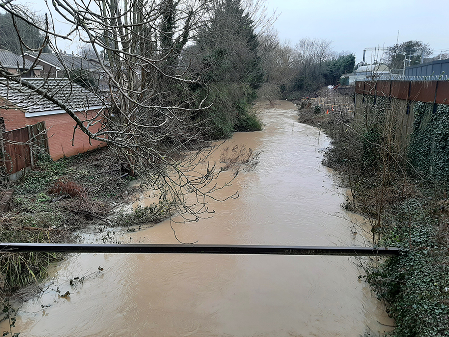
The report spends a lot of time describing what happened. As for why Thurrock Council think it happened, they’re saying that the flooding was the result of the months of December and January being the wettest recorded in the region in a hundred years. It was certainly wet – we really couldn’t have failed to notice just how wet it was! The rain in January was falling on ground that was already waterlogged. Any excess water had no where to go so flooding was inevitable. That much is true.
Mention was made of the issue of the sluices, with particular reference to the one at Purfleet, the failure of which led to floodwater back all the way up the Mar Dyke to Bulphan. Mention was also made of the fact that given the bean counters judgement that in their view, a low number of properties were actually threatened by flooding, the economic case for upgrading them is unlikely to be accepted by either the Environment Agency or their paymasters at the Treasury. Given that Bulphan has been identified by Thurrock Council as an area that has to accept a good few hundred extra homes as part of their effort to meet government imposed home construction targets, stating that there’s no economic case to be made for upgrading the sluice gate at Purfleet is incredibly short sighted.
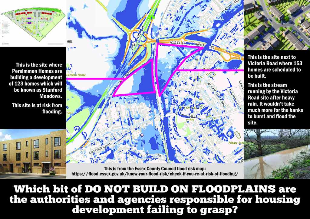
What’s striking about the report is what’s missed out in terms of potential contributory factors for the flooding, particularly in the case of Stanford-le-Hope where there are the long running A13 widening works plus the new home building in the area. A fair number of locals are convinced that the A13 widening works have drastically altered the way surrounding land in the area drains, thereby exacerbating the flooding risk. The new homes are putting the existing sewerage and drainage systems under extra pressure. One new development at Stanford Meadows is on flat, low lying ground adjacent to the Horndon Brook. The two ponds constructed by the developer, Persimmon PLC, on the eastern fringe of the development by the stream simply couldn’t cope with the amount of water and overflowed. New housing is planned for a site on the eastern side of the railway on land bounded by the Stanford Brook that runs behind Victoria Road. Part of this site gets waterlogged every winter and is to all intents and purposes, on a flood plain. None of this was mentioned in the report.
The report recommends the development of an Action Plan. On reading the suggestions for it, our thoughts are that it’s setting up a structure that will largely be reactive. Sure, there needs to be better co-ordination between Thurrock Council and the other agencies and authorities who have various responsibilities regarding flooding. However, out of nine points in the summary of the Action Plan, only three mention anything relating to prevention and they’re at the end. These are:
7. Where appropriate, engage with communities to develop community flood plans – e.g. Bulphan;
8. Ensure greater integration of flood risk matters into the Local Plan and future development;
9. Investigate and undertake enforcement action to prevent future flood risk.
The rest of the points are about how to react to the next flooding situation. From our point of view, prevention is vital and really needs to be at the forefront of anything Thurrock Council are looking at doing about future flood risk.
In a joint bid with Southend Borough Council to DEFRA and the Environment Agency, £6.4 million has been secured under the Innovative Resilience Fund. Thurrock Council will get about £3 million of this funding. The report states that this ‘is to investigate and implement innovative measures and techniques, rather than hard infrastructure, to reduce the risk of flooding’. This includes solutions such as “Natural Flood Management” to hold water in upper parts of the catchment area rather than allowing it to rush straight down from the hills towards lower lying, inhabited areas. This is a welcome step in the right direction. The disappointment is that it doesn’t sit in a more comprehensive overview of the cause of present flooding risks and how those could change in the future.
Any report on flooding has to take a holistic overview. We know it’s easy to say this from behind a keyboard and appreciate that such an overview would entail a lot of work and deep thinking. Such a report may well come up with conclusions that put the council and other authorities and agencies under an unwelcome spotlight. So be it. Any report that skirts around awkward issues such as inadequate planning processes and leaves residents at risk of future flooding is not worth the paper it’s printed on. Our conclusion is that this report is a disappointment, a lost opportunity and given what was missed out or dismissed, evasive.

2 Comments