

Why are we revisiting this issue?
It does seem to be the case that after each flooding event here in Thurrock, there’s a flurry of activity, talk and promises before the issue drops off the agenda again. Obviously, there’s some level of activity going on behind the scenes but what that is never gets properly communicated to residents who have suffered as a result of the flooding. This is one of the reasons why in order to ensure it stays on the agenda, we’re taking another look at the issue. Another is to try and convey what we see as the complexity of the situation and why it’s wrong to blame a flooding event on just one or two factors.
This is some of what we’ve written about the flooding issues across the south of Essex during the course of 2021:
Passing the buck:( – October 26, 2021
Not the holistic look at the January floods in Thurrock that we were hoping for – July 13, 2021
A question that needs answering – February 16, 2021
New housing developments and flooding – a pattern seems to be emerging – February 1, 2021
Draw your own conclusions… – January 30, 2021
After the flood…the questions… – January 16, 2021
A lack of joined up thinking = a clusterf**k! – January 14, 2021
That’s a lot number of posts on one issue… The explanation for this is that we live in a flood prone part of eastern Thurrock and as we’ve had a few near misses with flooding around our house, we’ve got a fair bit of skin in the game! The research we’ve undertaken so far to try and understand why we’re experiencing issues with flooding has been an interesting and revealing exercise. One thing it has shone a light on is the lack of joined up thinking from the local authorities and other agencies with a responsibility for flooding issues.
Climate change and mitigation
While we accept that climate change is happening and that rising CO2 levels are playing a role in this, we don’t go along with the apocalyptic rhetoric surrounding the issue which is having an adverse impact on attempts to have a rational, evidence based discussion about what’s happening to our weather. Some of the discussion around climate change is veering towards a misanthropic attitude that sees humanity as a problem – we have no time whatsoever for people espousing these views. Other aspects of the discussion focus on the need for lifestyle changes for the mass of the populace that would plunge the majority of us into an austere, life restricting poverty – again, this is unacceptable. We need to take a few steps back to enable a rational assessment of the issue and then proceed on a course of action that the majority of people are willing to buy into.
What does seem to be missing is a realistic discussion about measures that could be taken in the here and now to mitigate the impact of climate change. One such discussion that needs to happen concerns what action has to be taken to deal with an increased level of flooding. We’ve noticed changes in weather patterns which seem to be a contributory factor to some of the flooding events we’ve experienced. Let’s take the experience here in Essex of 2021 as an example. Over the course of the year, the rainfall has been pretty much average for what is the driest county in the country. However, we have noticed changes in how the rainfall comes.
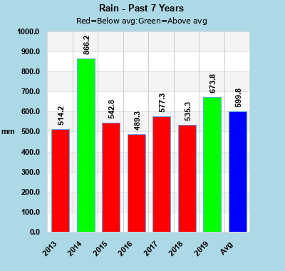
This graph of Essex rainfall levels is from the Chelmsford Weather Station
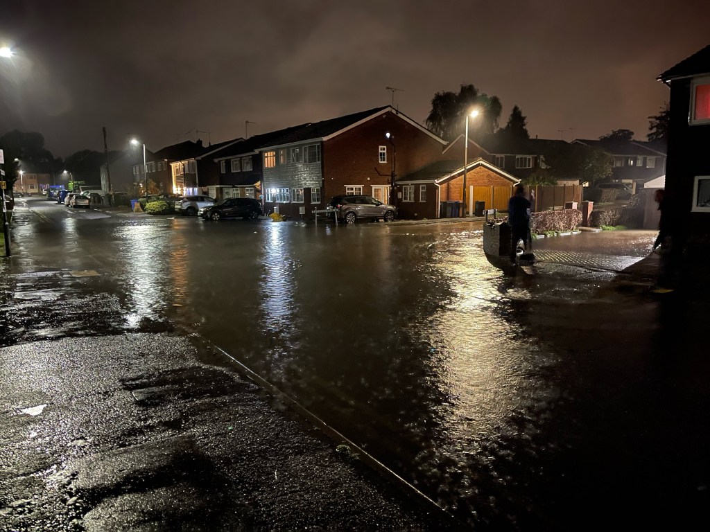
For example, we can go for a fair few weeks or even a month or more with very little rain then in a storm event, we get almost a month’s worth dropped on us in the space of five hours. This is what happened to us back in October 2021 when after a few hours of very intense rain, the drainage system in our neighbourhood gave out, flooding the road and surrounding our house and those of our neighbours with floodwater: Again FFS! – October 21, 2021
People could be forgiven for thinking that the relevant authorities simply take a look at the yearly rainfall totals, conclude that nothing significant has changed and seemingly ignoring how that rain gets delivered to us. In reality, there’s an acknowledgement of how weather patterns are changing but frustratingly, that doesn’t appear to be feeding through to policy making and implementation. In other words, there’s a lack of joined up thinking…
Talking the talk but not really walking the walk
One classic example of a lack of joined up thinking is our local authority, Thurrock Council, making what they think are the right noises about climate change – Council talking the talk on climate change and borough target of zero emissions – 28.11.20 – yet still giving permission for new housing developments on floodplains and other areas at risk of flooding. It’s all very well acknowledging that climate change is an issue but if mitigation of the impact of climate change isn’t factored into planning policy, then it’s nothing more than virtue signalling. Anglian Water who are responsibility for drainage and sewerage talk the talk about climate change and acknowledge that there’s an increase in intense rainfall events – Climate change. Yet when it comes to investing in their infrastructure so that they can cope with these intense rainfall events, Anglian Water (along with the other corporate utilities) do seem to be reluctant to dip their hands in their pockets.
What we appear to have is a fair bit of lip service being paid to the situation but little in the way of plans and action that will mitigate the impact of changing weather patterns and the increase in intense rain events. One frustratingly clear example of this is what appears to be a complete failure to stop building developments going ahead on floodplains and low lying areas prone to flooding.
Building on floodplains

As you can see from the above graphic, there’s a contradiction between Thurrock Council virtue signalling about climate change while continuing to allow housing developments to go ahead in low lying areas at risk from surface water and/or stream flooding.
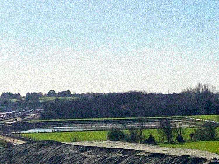
In Stanford-le-Hope, the Stanford Meadows housing development is slowly moving towards completion. While it’s not exactly on a floodplain as such, it has been built on low lying land bordered on the eastern edge by the Horndon Brook. Most of the time, it’s a pretty innocuous looking brook. However, after heavy rain it gets full and has been known to spill over. When the developers of the Stanford Meadows development, Persimmon Homes, held a public consultation event a few years ago, I went along to ask what measures would they take to eliminate the risk of flooding. That’s not just the increased flooding risk a new development would pose to the rest of Stanford-le-Hope but also to the estate itself. They said they would build a couple of attenuation ponds which they did.
It’s all very well Persimmon Homes saying at the consultation a few years back that as part of flood prevention measures, they would dig out attenuation ponds. What you can see in the above image is the bigger of the attenuation ponds. Ponds that during the flooding back in January 2021 couldn’t cope with the amount of floodwater and sent it down to the neighbouring residential streets of Butts Road, Poley Road and Kingsman Road. A pond that during the course of 2021 has been allowed to become choked with reeds, significantly reducing its holding capacity, thus increasing the risk of flooding, not only to neighbouring streets but also to the new development itself.
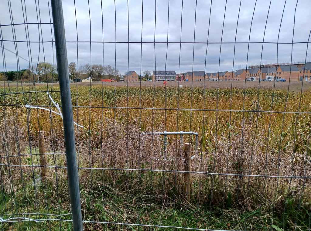
Then on the other side of the railway on what was rough meadow land between the railway line and Victoria Road, there’s another housing development by ilke Homes where construction has just started. The eastern side of this site is bounded by the Stanford Brook whose headwaters are up along the tops of the Langdon Hills. The lower half of this site frequently becomes waterlogged during the winter. Where site clearance and levelling work has begun, water is already pooling up – this does not bode well for the future. Some landscaping and an attenuation pond have been promised for the lower end of the site – whether these will be enough to deal with any increase in intense rainfall events is questionable to say the least. What’s happening is that we’re losing a rough meadow that did soak up a fair bit of water during the course of the year to a housing development with a lot of hardstanding – the question that has to be asked is where will that water go now?

Further to the west in Bulphan which experienced flooding in January 2021 when the Mar Dyke burst its banks, it transpires that the village will eventually have to accommodate a good few hundred new homes. Much all of Bulphan is prone to flooding. Even if the developers can avoid building on the most at risk locations, extra housing with the accompanying hardstanding means an increase in water that has to go somewhere in the event of heavy rain.
Tilbury has been a town that has always had issues with flooding, not just from surface water after heavy rain but on thankfully rare occasions, also from exceptionally high tides. With the issues that the town has with flooding, you would have though that Thurrock Council would be more mindful about granting permission for the developments that get proposed: Listen to the residents and act accordingly! – February 18, 2021
It’s safe to say that the majority of residents in Thurrock probably have a better grasp of where new housing should or shouldn’t be built on the basis of actually understanding what the flood risks in their communities are like. The problem is that the wisdom of residents always seems to come a long way behind the judgement of the council officers, a fair number of who don’t even live in the borough! As for the councillors, some of who would have local knowledge about flood risk, they need to get a grip on the council officers who, in theory at least, are supposed to be our servants.
It’s complicated
Building on floodplains has just been dealt with extensively in the section above as has any impact from climate change. It’s worth a brief look at what gets built in these housing developments. Over the decades, housing densities have been allowed to increase with the consequence that there’s less in the way of grass and other permeable surfaces that can absorb excess rainwater. With higher densities and more hardstanding, all of that rainwater has to go somewhere. If the developer has done the job right, it won’t gather on the estate and cause flooding there – let’s face it, anyone who is mortgaged up to the hilt for £350,00 or more is not going to be best pleased at seeing their new purchase awash with floodwater. So, the rainwater washing out of a high density development with a lot of hardstanding will inevitably find its way into neighbouring areas that are at a lower level, increasing their risk of flooding.

Over the decades, we’ve seen the loss of lawns/flower beds in front gardens to hardstanding parking provision. Also, there’s an expansion of patios/decking in back gardens. We understand why households often have to own more than one car because of working patterns, locations and commutes, necessitating turning over front gardens to parking. We also understand why people with busy working lives and other commitments want low maintenance gardens which inevitably involve hardstanding and fake lawns. The last thing we want to do is sit in judgement of people’s personal choices when all they’re trying to do is live the best life they can under the current system. However, when paved over front gardens and back garden with reduced areas that can allow rainwater to soak away become ubiquitous, we need to have a conversation about what can be changed.
Then there’s theA13 widening… Getting away from the project being over-budget and delayed, there are questions over what the works have done to the water table in the immediate area – questions which Thurrock Council have unsurprisingly, evaded answering: Water mystery. Council keeps cards close to its chest over Stanford-le-Hope flooding but emphatically states that it has nothing to do with A13 widening project – 09.03.21. We’re not civil engineers or hydrologists but when you see the extent of what’s being done with the A13 widening, part of which includes an ‘attenuation’ pond on the north side of the junction with the Manorway and east of the B1007 (see the image below), it’s reasonable to want answers to questions about changes to the hydrology in the immediate area. As it’s a Thurrock Council sponsored project which has had more than it’s fair share of ‘issues’, while it’s frustrating and disappointing, it’s not surprising there’s been evasiveness about the A13 widening possibly contributing to the flooding.
As the title of this section indicates, there’s a complex range of issues causing the flooding we’re experiencing. Complexities which the ‘report’ Thurrock Council delivered didn’t investigate in the way they should have been: Natural events blamed for Thurrock floods – with Environment Agency and council playing down concerns about mechanical failures, roadwork impact and more houses. But a new action plan is in place and £3 million will be spent on defences. The lack of joined up thinking and the failure to make links suggests a pretty deep malaise with the system we have to endure. It certainly suggests failures within higher and university ‘education’ which lead to the evasive dross that Thurrock Council served up to us with their ‘report’ into the flooding issues. We’re grassroots activists, not educationalists so that investigation/discussion is best left to those with the knowledge, experience and expertise to explain why people with degrees produce this dross.
Solutions?
We’re not going to get people who can do proper, joined up thinking, analysis and solution development and implementation until the education system has been fundamentally rebuilt from top to bottom. That won’t happen until we get far reaching social change where power comes down to the grassroots and we get an education system that meets our needs, not those of the elites. That’s for the future, hopefully not too far into it… What we want to focus on in this section is solutions that can be implemented in the here and now or in the near future. Mind you, to even get some of these implemented is going to require the proverbial boot up a few backsides!
The first solution has to be reform of planning legislation that makes it easier for councils to refuse permission for housing developments in low lying, flood prone areas, without fear of the developer appealing the decision. In theory, this would give local councils more say in how their communities grow and develop and if the councillors have achieved the necessary degree of supervision over their officers, it adds a degree of democratic accountability to the process. Regardless of what happens with climate change, just looking back at the historical records should provide enough evidence to prove that building on low lying areas prone to flooding is not a good idea unless robust flood alleviation measures are in place.

There has been some discussion of using ‘natural’ methods in the upper reaches of the streams that flow through Thurrock that have flooded. While it’s highly unlikely we’ll see the introduction of beavers to build dams and the like in these reaches, judicious human intervention could achieve a similar result. With some of the headwaters of the Mar Dyke rising in Thorndon Country Park, there’s scope to enhance some of the water retention measures that already exist there. With some of the headwaters of the Stanford Brook rising in Langdon Hills Country Park, part of which is managed by the Essex Wildlife Trust, there’s scope for damming and other measures to slow the flow of rainwater down from the hills. As for the middle reaches before they reach any of the built up areas, while it would require some negotiation with the farmers, the construction of a number of attenuation ponds and other overflow solutions to slow the flow of water is a possibility.
A brief word about farming practices… We don’t want to name names but there are a number of farmers in the area who seem to belong to the ‘prairie farming’ fraternity. While it may not be aesthetically pleasing, if the vast prairie field is dead level on a river plain, it won’t cause many problems. However, if you’re like a certain farmer to the south of Horndon-on-the-Hill who seems to have a bit of a tree and hedge phobia and sees nothing wrong with vast fields on slopes, maybe it’s time for them to review their practices. In the aftermath of the flooding in January 2021, we walked past one of the fields on the farm that runs down to Pump Street and a few hundred yards of the field at the foot of the slope were waterlogged and choked with silt washed down from the upper reaches. Silt which was also washed all over the road. High time for a bit of a re-think…
Earlier in this piece, we mentioned the increase in hardstanding in the more established suburban areas as front gardens are paved over for parking and back gardens patioed or hard decked for leisure purposes. Front gardens are paved over because a growing number of households run more than one car. In an area where public transport isn’t brilliant and working patterns tend towards being 24/7 giving people little choice but to rely upon cars, there’s no realistic chance of many front gardens being restored to permeable lawns or flower beds as car ownership drops back down to one per household. So we have to look at making hardstanding areas more permeable to rainwater can soak away rather than rush straight off into the road. A swift search on the Net revealed an encouraging range of permeable surfaces that can be used for front garden parking. Yes, this is a technical fix but at this point we’ll take it because it can be one of many incremental changes that taken together overall, could make a significant impact in reducing flood risk.

Obviously, the only long term solution is radical social change where power is brought right down to the grassroots and it’s residents in their communities making the decisions about how they develop and thrive. This may be anathema to those who see the only solution as coming from the top down, even if it has to be imposed. As we can see from the growing tensions over Covid lockdowns and restrictions, imposed solutions rarely work. Given that the residents of Thurrock have shown more common sense about, and understanding of the issue of flooding, we think they’re better placed to make those decisions than council officers who don’t even live in the borough.
Conclusion
As stated at the start of this piece, as we live in a flood prone neighbourhood, we have plenty of skin in the game regarding this issue. Although this issue is very personal to us, we hope we’re able to take a few steps back and look at the political, social and economic implications of the flooding issue. These range from the need to have a rational discussion about climate change and what can be done to mitigate its impact through to making the planning process more accountable to residents. What we’re trying to do with this piece is to start pulling all of these strands together to develop some kind of overview. The more we as resident activists can understand about the flooding we’re experiencing, the better a position we’ll be in to campaign and lobby for some action that at the very least will alleviate the risk. We’re not going to pretend that this piece offers all the answers or even an analysis of the situation. It’s our imperfect attempt to understand what’s happened to us and to suggest some possibilities for solutions. As such, we’re willing to be corrected if it will help with the above objectives.

Reblogged this on and commented:
An in depth review from our sister blog… There are still a LOT of unanswered questions regarding the flooding issues that have afflicted Thurrock and we want answers…
LikeLike